Thursday, October 30, 2014

Rainbow Trail by Mountain Bike- Bear Creek to Kerr Gulch

As you can see reading this blog I enjoy the outdoors.  While I like to get outside to hike, bike, ski, or do anything in the mountains, not every trip is a winner.  Sometimes I encounter unexpected conditions and have to abandon a trip because of a thunderstorm or other reason.  I usually don't mind these trips too much because it comes with mountain travel.  Hiking I don't normally have too many trips that stand out as an unpleasant outing.  One that does stand out was a trip on Vermont's Long Trail a few years ago where it rained days on end on top of an already saturated trail and my feet were destroyed from the never ending moisture.  I ended calling it quits after 190 miles.

I am more likely to have a less than stellar trip it when mountain biking.  Most any trail can be hiked, but not so much mountain biking.  An excessively muddy or poorly riding rocky trail can really put a hamper on my fun.  My most recent ride was one of these rides that I didn't have a great time.  Part of the reason was the trail itself wasn't what I was expecting.  Another reason was this section of trail paled in comparison to the last 6 or so rides I have ridden.

The Rainbow Trail runs nearly 100 miles along the east side of the Sangre de Cristo Range.  The Rainbow Trail has been the closest riding to both of my houses that I have lived in since I moved to Colorado.  Before I moved here I heard about riding the Rainbow.  I find the riding on it hit or miss, mostly miss.  The northern most stretch of trail near Salida from the Bear Creek trailhead to the northern terminus features fun and flowy singletrack most of the way with just enough technical riding to keep it interesting. On the rides on the Rainbow south of here, I haven't had much luck finding a good ride.

I live just below the Rainbow Trail section that runs from Bear Creek to Kerr Gulch.  I never rode this stretch of trail but wanted to try riding it since the Kerr Gulch trailhead is only a few miles from my house.  The section north of Bear Creek sees a fair amount of traffic and for good reason.  It's a fun and fast stretch of singletrack.  I thought some of this fun trail would continue south of Bear Creek.  I was terribly wrong.

My ride started a couple miles below the Rainbow Trail on Fremont County 49.  For nearly the first 3 miles I followed this progressively rougher dirt road uphill to the Rainbow Trail.  While the road gets rougher, it never is too difficult.  The road ends at the Rainbow trail.  I took a left and headed south toward Kerr Gulch.  Almost immediately the rocks began.  Most of the rocks were at least baseball size or larger and very loose.  It was difficult to hold a line and get enough momentum to muscle through the rocks even though the trail wasn't too steep.  The trail climbed for the most part for at least 2 miles before topping out on a ridge.  This was nearly 5 miles of climbing from the start.  The climbing itself wasn't that severe despite a decent elevation gain by this point.  It was the rocks and ruts of the trail with absolutely no rhythm that made it difficult.

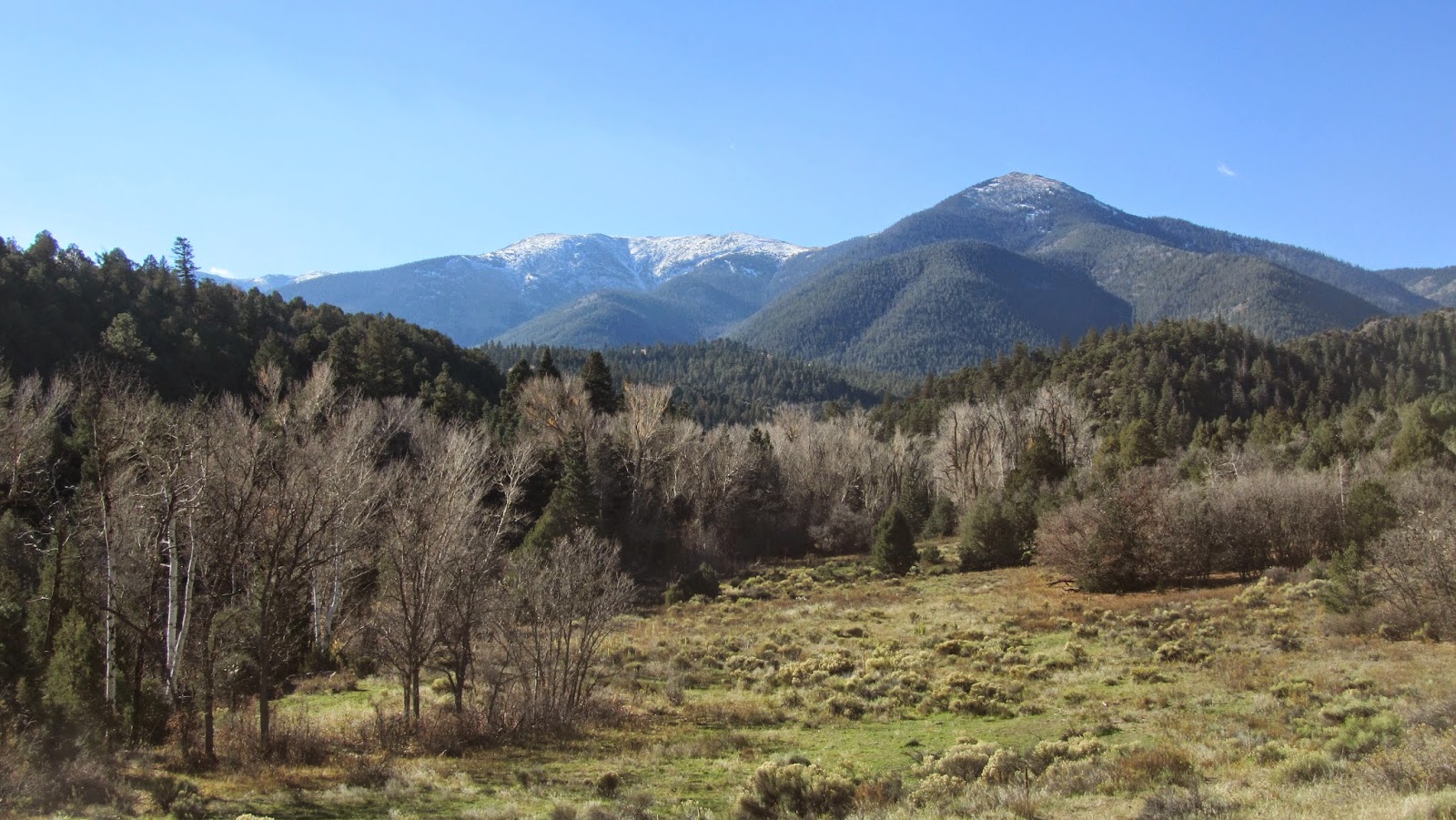
View of the Sangres near the trailhead
Start of the riding on the Rainbow Trail
Loose rock early on the trail.  This wasn't an uncommon sight on this ride
I was looking forward to the descent after the rough climbing.  The descent was much worse than the climb.  The descent was much steeper than any of the climb.  The trail was extremely washed out and rutted.  There were more rocks and much looser.  There was no line to follow.  Since the rocks were loose, they moved as you hit them causing me to bounce quite a bit and sending me on an even worse line.  One section was so rocky, steep, rutted, and washed out that I had to walk down it.  My hands cramped from riding the brakes downhill to maintain speed.  I have mountain biked for over 20 years now down some substantial descents but this was about as ugly as I have seen.

Top of the first ridge
First descent and best view of the ride.  The trail got nasty as it descended deep into the woods.
This was the norm for most of the ride.  Occasionally the trail would level out on a beautiful stretch of singletrack but it never lasted too long.  When the downhill ended I would reach a creek and climb up and over the next ridge to the next creek.  While most of the trail was rideable,  There was no flow at all to the trail.  It was long climbs with loose rock and ruts followed by bone jarring descents. Because the descents were so rough, I really didn't have much speed coming down them.  The trail was singletrack and there wasn't room for error with all the rocks and trees.  The trail often followed a steep side cut so a fall could have been disastrous, especially since this section of trail is remote and doesn't see much traffic.

One of several creek crossings
More rocky uphill
From the trailhead, the conditions mellowed some after 7 miles or so.  This is where I hit the occasional section of nice singletrack.  The total ride on the Rainbow Trail was a little more than 12 miles.  I don't think I had more than three miles of enjoyable riding and the little bit of nice riding wasn't worth the rest of the trip.  I was amazed at how different the trail conditions were on this side of Bear Creek.  The few flat sections of trail were surprisingly smooth.  I don't know how the climbs and descents had so many rocks.

One of the few fast flowy sections
Maybe 2-3  of 12 miles looked like this on the Rainbow Trail
Another brief nice stretch
Then back into the rocks for several miles
This section of trail wasn't rocky but I put my bike
in the shot to see how deeply the trail washed out.
The trough in the middle of the trail is nearly two feet deep.
Finally after 14 miles, I reached the Kerr Gulch Trail that descend away from the Rainbow Trail. Although less than a mile, this was just as bad as the Rainbow.  It dropped quite steeply and was extremely littered in loose rocks the size of baby heads.  The last 5 miles or so descended quite quickly down Kerr Gulch Road.  Kerr Gulch is fairly steep dirt road, dropping a couple thousand feet in 5 miles.  Because it gets quite windy and has some gravel on it, I had to keep my speed in check to maintain control.  I was cramping in my wrists and forearms from using my brakes so much especially since I am not riding discs.  With my hardtail, my upper body was somewhat stiff from absorbing the rocks on the 4700 feet of descent on this ride.  

I finally reached US 50 at the end of Kerr Gulch after riding 19 miles.  It took me over 3 hours. Before I got to the fast descent on Kerr Gulch Road, my average speed was less than 5 miles an hour. This ride climbs nearly 3500 feet but it doesn't seem like it because the 4700 feet of descent was so long, rough, and drawn out I forgot about the climbs.

With so many great rides close to Salida, I wouldn't recommend this ride.  Stay north of the Bear Creek on the Rainbow Trail and you will have a blast.  This was a rough ride and the rewards were not worth the unpleasantness.  There were some nice views of the Sangre de Cristos, but to be honest, you can get better views driving along US 50 through Howard than the short glimpses of the peaks that I got on this ride.  If you want solitude, you'll find it on this ride but I have found solitude on much more worthwhile rides around here.  If you want a relentless technical ride with no flow, by all means check out this trail section.  My local riding guide seemed to give this ride a little more hope but perhaps the trail has deteriorated since the books printing 6 years ago.

One of the views of the Sangre de Cristos along the trail
There wasn't enough scenery to make up for the lackluster trail
My other rides further south on the Rainbow Trail have been similar.  Riding the Rainbow feels like riding a dry riverbed with its rocks followed by rather short sections of decent riding and then more relentless rocks.  Much of the southern Rainbow is ridden by ATVs and the entire Rainbow is used by dirtbikes.  Some areas are quite heavy with their traffic.  I'm guessing  they add some to the trails deterioration.  As a mountain biker, I recommend leaving the southern sections to the ATVs and dirt bikes and enjoy the Rainbow's nice sections north of Bear Creek.


Friday, October 24, 2014

Oil Well Flats: Fun Desert Singletrack

A cold sidelined me from any outdoor activities the past couple weeks but I finally felt good enough for some outdoor fun this weekend.  With warm weather, a mountain bike ride seemed like my most appealing option.  A lot of the higher elevation trails are still snowy and muddy so my sights were set on a lower ride.

Originally I planned on a ride near Salida.  I had an errand to run Canon City however .  A fairly new trail system called Oil Well Flats just outside of Canon City seemed to have potential.  Most trail reports of the area had good things to say about the riding.  I decided to combine my errand with a mountain bike ride.

The drive from my home in Howard to Canon City travels along the Arkansas River through Big Horn Sheep Canyon.  Like the name implies, there is a sizable population of the sheep in the canyon.  I have seen sheep several times driving through the canyon in the past.  On my trip Sunday morning, I saw three separate herds with a handful to a dozen sheep in each herd.  I always enjoy seeing the sheep but this time the sheep were lingering in or very close to the road.  The first herd was off the road a safe distance.  I came close to hitting sheep that were in the road or right along the shoulder in the second and third herds I passed.  Because of the windy nature of US 50 through the canyon, wildlife isn't always visible until the last minute.  Unfortunately I wasn't able to get any pictures since I nearly hit the sheep and they ran away.

After my sheep safari, I arrived at the first trailhead at Oil Well Flats, just a few miles north of Canon City.  Canon City sits lower in elevation and is in a warm area.  It is often as much as 20 degrees warmer than where I live in Howard.  The area is also very dry and is basically a high desert.  This makes the area a good choice for riding in the fall or spring and is often free of snow most of the winter.  

My ride followed a suggested route from the Lower Arkansas Mountain Bike Association, the group that builds and maintains the trails at Oil Well Flats.  From the trailhead, at just under 6000 feet in elevation, my ride  followed singletrack trail.  The trail winded and twisted for nearly two miles while gradually climbing on a trail called Tectonic Shift.  The singletrack had nice flow to it with a few sections of rock to keep it interesting.  Cacti was common right along the trail and I had to be careful not veer the trail so I didn't ride through any cacti.  At one point I got a couple of cactus needles in my foot through my shoe from a plant on the edge of the trail.  Another rider at the trailhead managed to crash onto a cactus and was full of needles and not too happy.  After two miles I reached a section of doubletrack that I followed briefly before hitting the next section of singletrack.

Blooming cactus
Another blooming cactus
One of the short sections of doubletrack
I traveled a short distance on a trail called Anticline before reaching Unconformity.  Unconformity had about 3 miles of singletrack that continued to wind through the desert landscape.  Unconformity was more technical than Tectonic Shift and climbed gradually the entire time.  Plenty of pokey desert vegetation lined the trail.  There were more rock features to navigate as I climbed Unconformity.  The trail traveled through scrubby pinon forest part of the time while traveling through an old burn area the rest of the way.  In the open burn area, the views opened up taking in the arid landscape around Canon City and reached as far as the snowy Sangre de Cristo Range.  I passed by interesting rock formations on Unconformity and some of the rocks were incorporated into the trail. I rode toward, then around, sections of cliff rising more than 200 feet.

Scrubby landscape
Riding toward cliffs
Climbing on Unconformity
Singletrack passing rock
Cactus on edge of trail
Another look at the cliffs
The trail meandered through rock formations
Unconformity with dead trees in an old burn area
More scrubby vegetation in the old burn
A short jaunt on another section of doubletrack after Uncormity brought me to a trail called Island in the Sky.  Island in the Sky was the most diverse and scenic section of trail.  The trail was about three miles long and entirely singletrack.  It started winding through forest,  then trail broke out of the forest and began climbing a ridge.  Although it was the steepest climb of the ride, the excellent trail made the climbing fairly easy.  The trail reached the top of the ridge with far flung views in all directions with the Sangre de Cristos in the distance making an impressive backdrop.


Near the start of Island in the Sky
Climbing along Island in the Sky
Nearing the top of the ridge
Top of the ridge
Looking back along the ridge
The Sangre de Cristos in the distance
From the top of the ridge, the most technical riding of the trip began.  The trail immediately became more rocky as I descended.  The slope was in the open and offered nice views of the valley below where my ride began.  As the rocks became more common, I popped out onto the top of the 200 foot cliff I saw earlier on the ride.  The trail followed the top of the cliff no more than 10 feet from the drop at times.  The trail at this point was entirely rock and at times a little tricky to follow with no real tread.  After a short distance the trail turned away from the cliff top and was more trail like but quite technical.  The steepest part of the ride followed and I descended quite quickly over a mix of fast singletrack and technical sections.

Starting to descend
The trail follows the top of the cliff with 200 foot drop
Looking back across cliff
Another look back at cliff and rocky stretch of trail
View toward Canon City
The trail is still rocky but more mellow as it leaves
the cliffs on Island in the Sky

I had my only incident on this section of the ride.  I cut a turn tightly and brushed against a harmless looking bushy tree.  The bush however wasn't very forgiving.  A stick from the bush wedged between my frame and chain and stopped me dead in my tracks with the stick jammed in there pretty good.  It took some work to get it loose.  In the process, my lower leg got pretty scratched up and bled a bit.  It was nothing serious.  It looked worse than it was until I had a chance to clean up the scratches and blood.

At the end of Island in the Sky I followed the Fire Canyon Trail shortly back to the start of Island in the Sky.  From there I retraced my route to the trailhead following Unconformity, Anticline, and Tectonic Shift.  In reverse the ride was almost entirely downhill and a blast to ride.  The ride was about 14.4 miles and I think all but a half mile or so was singletrack.  I don't have the exact elevation gain but I'm guessing it was more than 1500 feet of total climbing.  The total ride took me just under 2 hours.

Even though it was a relatively short distance, this was an awesome ride.  The trails were nicely laid out and a ton of fun to ride.  The Lower Arkansas Mountain Bike Association (Lamba) has done a great job building these trails and continues to expand the system.  In general I would consider it intermediate riding but there are definitely a few sections that I would consider advanced, particularly the descent on Island in the Sky. Canon City tends to be quite hot in summer so I wouldn't recommend this in the summer.  This trail system probably has the one of the longer riding seasons in the Front Range and I highly recommend riding it.  On a nice, sunny Sunday with temperatures in the mid 70s I saw only a handful of other riders on the trails.

The Sangre de Cristos can be seen from many sections on the ride
There is a kiosk at the trailhead with a map and all the trails and roads are signed.  I highly recommend getting a new map if you do ride here.  The map I have on the link below is current.  Nearly every website with Oil Well Flats trail descriptions uses the old trail names.  Even the kiosk had the old trail names.  Most maps I have found online list Tectonic Shift as Pebbles and Bam Bam.  Unconformity was called Ms Spike and Island in the Sky was called Cat's Pajamas.  I didn't have trouble route finding with the old map.  I just want to throw this out there as a heads up to anyone that might ride Oil Well Flats.

Click the link below for the map of my ride.  My route followed the black arrows on the map.
Map

Thursday, October 2, 2014

Mountain Biking Lookout Loop and the Crater

Puma had to go to work for a few hours while I had the day off on Tuesday.  I was looking for some outdoor fun close to Salida while she was working.  There are numerous mountain bike options accessible from town in Salida that I could ride.  Recent snow fell on the higher summits so I wanted a ride with views of the higher peaks.

From my local cycling guide, a couple of trip options came to mind.  The first is a ride into the Arkansas Hills east of town called the Lookout Loop, which as its name indicates looks out over the Arkansas Valley.  Another trip of interest is a ride to the Crater.  The Crater, while not actually a crater, is an interesting geographic feature that I wanted to see.  From downtown Salida the Crater is visible as a section of white rock in an otherwise reddish background.  The ride to the Crater starts along the Lookout Loop trip so I decided to combine the two rides.

I dropped Puma off at her work in Salida and started my ride from there.  I had a couple miles of easy riding through town to reach the start of the Lookout Loop.  The loop starts on Country Road 175 and follows it for about 6.5 miles.  The first two miles are paved before turning to dirt.  The dirt road is well maintained and quite windy as it climbs more than 1500 feet before reaching County Road 181.

CR 181 marks the beginning of the ride to the Crater.  Upon reaching CR 181 the route becomes slightly rougher.  Just over a mile on CR 181 you pass CR 173 and split from the Lookout Loop route and continue toward the Crater.  By now the route reaches 9000+ feet, 2000 feet higher than the start of the ride, and the views begin.  While the first 7 miles were all uphill, the ride features a lot more up and down riding on the ride to the Crater.  About 2 miles from the 175/181 junction the route turns on to CR 181A.  CR 181A is even rougher than the previous roads and feature sections of loose climbing.  The views are far reaching along most of the road ranging from the Sangre de Cristos to the south to the peaks of the Sawatch Range outside of Buena Vista.
  
Views along CR 181
(Clicking on photos will enlarge them and make them easier to see)

The vegetation is scrubby in the Arkansas Hills
Big view of the northern Sangre de Cristos
wearing a new coating of snow
After riding almost 4.5 miles from the 175/181 split, The summit of the Crater is reached.  Without a trail guide or someone familiar with the area, the route to the Crater can be tricky to follow.  From CR 181A, there are a couple more turns and the junctions aren't marked.  Without a cyclometer to measure mileage and the guidebook, I'm not sure I would have found the Crater because not all of the roads were on my map.  I actually took a wrong turn that ended at gated private property and added nearly 2 miles to my trip and a couple hundred more feet of elevation gain.  The last road became quite rocky and the final ascent up the Crater is quite steep and eroded and mostly unrideable.  Even if you can climb it, I recommend walking it to eliminate further erosion to the loose trail.

The backside of the Crater doesn't look like much
The final pitch up the Crater is steep and nasty
The Crater is an interesting place.  It isn't really a crater from a volcano or meteor.  It is more of a bowl that is open on one end.  Three sides are surrounded by steep terrain, while the side facing the valley is open.  Most of the area is red soil but the rocks that make up the back of the Crater's bowl are white, which makes the area stand out from the valley.

Looking over Salida from the Crater
Another view near Salida from the Crater.
Salida airport is visible in the bottom right corner.
From the Crater, at 9200 feet, the views are quite impressive.  The entire sweep of the upper Arkansas Valley from the northern Sangre de Cristos to Sawatch Range above Buena Vista is visible.  The city of Salida sits some 2000 feet below.  Some of the higher summits just barely touched the clouds, while some were obscured.  All of the higher mountains wore a fresh dusting of snow from the day before.  It was quite windy as I stood at the Crater.  The thermometer on my cyclometer read 50F, but with the wind it felt much cooler.  I enjoyed the view while eating a snack before heading back toward CR 173.

View across the Crater with some of the white rock in the foreground.
From town, the white rock around the Crater is visible some 2000 feet below.
Another look across the Crater with the
Sawatch Range in the background barely in the clouds.
A close up of the Sangre de Cristos from the Crater
The ride back retraces the same route.  The elevation profile for the Crater ride resembles an EKG chart.  The entire out and back is less than 9 miles and gains more than 1000 feet in elevation in a series of continuous ups and downs.  Even though it travels dirt roads, the ride fairly technical at places with sections of rock, loose trail, and washouts.  Most of the time however there are views looking at the 14ers of the Sawatch Range.

Looking into the scrubby Arkansas Hills
from the backside of the Crater
The Sawatch Range on the return from the Crater
Close up of Sawatch Range toward Shavano and Antero
Instead of returning to CR 175, I turned down CR 173, which continues the Lookout Loop.  CR 173 starts as a somewhat rough dirt road.  While it mostly descended, there are some sections of climbing.  The further I traveled on CR 173, the rougher it became.  It eventually changed from a dirt road to rough double track trail.  It descended steeply in places and became quite rocky.  It descends between Dead Horse and Cottonwood Gulches, crossing numerous washes along the way.  As the trail got lower in elevation and closer to Salida, it became quite gnarly and technical in places.  A beginner mountain biker might be intimidated by some of the rough rocky stretches on the lower reaches of CR 173.  Eventually the backside of Salida's S Mountain comes into view.  CR 173 eventually skirts the north side of S Mountain before reaching CR 176 and finally CR 175 to close the loop after 8+ miles.

Another nice look at the Sangres from the top of CR 173
CR 173 often rides along the rim of the gulches
View over the valley toward Sawatch Range
(This one looks better if you click to enlarge)
Close up of  the Sawatch Range toward Shavano and Antero
CR 173 gets quite rough and rocky as it gets lower
Solid layer of exposed rock on CR 173
CR 173 is a fun downhill.  The only thing it is missing is sections of singletrack.  At the lower reaches of CR 173, I could have accessed the Salida Mountain Trails system and had my singletrack fix but I was running short on time so I stuck to the main route  There are great views of the Arkansas Valley and the mountains surrounding the valley at many points along the ride.  The views into the gulches surrounding the route are quite interesting as well.

View over Salida from the lower part of CR 173
The back of Tenderfoot "S" Mountain and Salida
(much clearer if you click to enlarge)
By the time I got back to my car, I rode more than 28 miles and was on my bike nearly 3.5 hours.  I could have shaved off several miles if I parked downtown and didn't take the wrong turn.  Despite following dirt roads most of the time, this ride was more challenging than I expected.  The total climbing on the ride was substantial between 3500 and 4000 vertical feet.  The lower reaches of CR 173 are quite technical at times. Nonetheless it was a fun ride with plenty of nice scenery.  I plan on riding parts of Lookout Loop again soon.  There are sections of singletrack trail through Cottonwood Gulch as well as the Salida Mountain Trail System around S Mountain that I will explore in the future.  

The Lookout Loop and the Crater ride don't have to be ridden together.  I would probably classify both as intermediate rides.  Riding them together I would consider it an advanced ride with the distance and elevation gain involved combined with sections of technical riding.  I wouldn't recommend CR 173 to anyone uncomfortable with technical riding however.  By itself, the Lookout Loop trip is about 18 miles and the Crater ride is just under 9 miles. Lookout Loop however climbs more than 2500 feet compared to 1300 on the Crater ride.